


River Access Points
Looking for established river access points? We have got you covered. Since 2018 UMATR has been working with Northern Forest Canoe Trail Stewardship Crew to add new access points to the Missisquoi and Trout Rivers. This includes permanent stone steps or removable wooden steps. Each summer we have added a new established access point to the river. Do you know of a spot on the Upper Missisquoi and Trout Rivers that could use an access point? Let us know. Learn more about the access points below!
Use this map to identify some of the access points along our Wild and Scenic Rivers. Zoom in and scroll around to see more.

Navigating the map:
To zoom, use the + and - icons on the bottom left. To scroll simply click and drag your cursor. To open the legend, click the icon with the arrow in the top left corner. Click on the icons on the map to see more details. You can view the map in a larger window by clicking the rectangle in the top right.
UMATR Access Points
Flow downstream with our access points starting in Lowell and ending in Enosburgh!
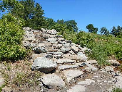
Lowell VT 100 Access Point Est. 2019
44.834187, -72.432837
These stone steps are at the start of our Wild & Scenic Designation located in Lowell and will take you to the Missisquoi River. Park at the road pull off on the side of RT 100 as you cross the Lowell/Westfield line.
Lane Road Access Point Est. 2018
44.886192, -72.410939
These removable wooden steps are located in Westfield on Lane Road. Do not block the road and use the trail by the sign leading to the access steps. Park in the grassy spot designated by the parking sign.


River Road Access Point Est. 2022
44.916944, -72.396778
Located off of River Road in Troy. A large gravel parking area with a set of stone steps will lead you to the river. Dam immediately downstream; do not paddle downstream from this location.

East Richford Access Point Est. 2023
44.997421, -72.610957
Park at the road pull off on Glenn Sutton Rd, just off of Rt 105 in East Richford. Stone steps lead way to wooden river access steps.


Davis Park Access Point Est. 2020
44.997807, -72.675937
Located in Davis Park, Richford, just below the river rapids in the center of town. Park in parking lot and walk to stone steps.
Riverwalk Park Access Point Est. 2018
44.90183, -72.65089
Park at Riverwalk Park parking lot and walk down stone steps into the river. These stones steps offer access to the Trout River and is a popular swimming hole destination. From here, you can paddle 6 miles down the Trout River to the confluence of the Missisquoi.


East Berkshire Horseshoe Road Access Point Est. 2024
44.95396, -72.69861
Located just before the Missisquoi Valley Rail Trail Bridge. Park on the side of the road by the grass. Walk down the path to the stone steps- watch out for poison ivy!
_HEIC.png)

East Berkshire 118 Bridge Est. 2025
44.93391, -72.70913
The newest river access point- installed in July 2025! Park at road pull over on 118. Walk through the grass and down to the river. Directly across from UMATR/MRBA office.

Missisquoi Street Access Point Est. 2022
44.908201, -72.796577
Drive in from Missisquoi Street in Enosburg Falls and park your car just before the walking trail. Stone steps and a boat put-in are just before the river. This access point also connects you to the Brownway River Trail.


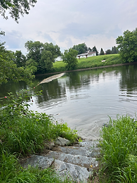
Lawyers Landing Access Point Est. 2021
44.902428, -72.805727
These stone steps are located in Enosburgh. The Enosburgh Dam is immediately downstream of this access point; do not paddle downstream from here. Park at pull off on side of 108 before crossing the river.


When using these river access points, please respect the landowners who allow us to create these access points: do not leave any litter behind during your visit, and please do not block any farm access roads if you are leaving a vehicle.